
---
Scott Dillon
BASc Golf Course Management
Project Description
Directed Field Study #3 - Golf Course Digital Mapping
Create digital mapping of golf course using GIS software to allow for adjustments to be made to cultural practices as well as fertility and pesticide applications.
-
Use GPS device to map all areas of the golf course
-
Overlay details from GPS mapping on aerial photo of the property.
-
Use details to compile a complete inventory of all golf course aspects including;
-
Areas of;
-
Greens
-
Tees
-
Fairways
-
Rough
-
Ornamental Areas
-
Naturalized Ravines
-
-
-
Use details gathered to adjust areas and application rates of fertilizer and pesticide applications.
-
Validations:
-
Employer validation letter
-
Complete GIS data overlaid on satellite imagery.
-
Adjustments to fertility application rates for greens and tee sites across the property based on the newly calculated areas.
-
-
Project Updates
Under this heading you will find details pertinent to the completion of this goal. This section will effectively work as a type of blog used in the completion of the third directed field study goal:
DFS 3 - Golf Course Digital Mapping
Update 1 - Opening Remarks and Software Establishment
When creating a digital map of a golf course, the first step would be to secure a high quality aerial image of the property. After hours of searching, the best image I could find was one supplied from Valtus. Valtus is a leading source for geospatial and LiDAR imagery. The relieved image, as well as the Valtus website link is located below.

Once an appropriate image was located with the desired GPS coordinate system, these aspects can be loaded into GIS mapping software. For this project I have decided to use the QGIS software on my Mac computer. I was first exposed to this software during year three of the applied degree program. The software has numerous tools to complete analysis on every aspect of the property. Additionally the QGIS software is able to transcribe from the previously collected GIS cloud coordinates which can prove to be advantageous when inputting already captured features and their respective attributes.
Update 2 - Golf Course Greens and Tees Digitally Mapped
Digitally mapping golf course aspects helps dramatically when attempting to calculate the amount of fertilizer or pesticides to purchase for the year. While the knowing the areas for the entire golf course is important, arguably the most important is knowing the size of your greens and tees. These areas are the areas where the most attention is given by staff as well as the areas where the golfer spends the most time during their round.
Using the GIS software, all greens and tees have been successfully digitally mapped. The software calculated areas are displayed in the chart below.
Hole: Green Area (m2): Tee Area (m2):
1 900.90 895.38
2 585.15 582.61
3 533.39 723.45
4 682.13 506.44
5 703.56 871.27
6 742.51 626.15
7 684.90 612.54
8 739.36 791.07
9 921.79 532.50
10 931.61 0.00
11 691.05 348.32
12 562.13 591.07
13 451.21 988.44
14 999.57 148.53
15 917.03 423.55
16 741.85 572.35
17 321.46 586.74
18 481.68 181.45
Practice Green 1087.85
Nursery 617.44
Totals: 14,296.57 9,981.86
In the picture below, greens are marked in Green and tees are marked in Red

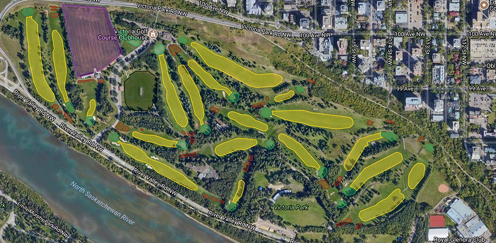
Update 3 - Golf Course Fairways and Driving Range Digitally Mapped
Using the GIS software, all fairways and the driving range have been successfully digitally mapped. The software calculated areas are displayed in the chart below.
Hole: Fairway (m2):
1 5,697.05
2 4,746.59
3 1,295.63
4 7,244.91
5 10,534.75
6 6,615.36
7 990.20
8 3,273.77
9 7,240.62
10 4,104.16
11 8,460.37
12 0.00
13 9,729.25
14 6,538.75
15 4,520.45
16 9,984.78
17 1,268.34
18 12,698.78
Total (m2): 104,943.76
Driving Range (m2): 31,000.00
In the picture below, fairways are marked in Yellow, and the driving range is marked in Purple
Update 4 - Golf Course Natural Areas and Ravines Digitally Mapped
Using the GIS software, all natural areas and ravines have been successfully digitally mapped. The software calculated areas are displayed in the chart below.
Area Details: Size (m2):
Right Side of 16th Hole 8,639.21
Between 6 and 7 2,589.59
Right Side of 7 2,987.18
Left Side of 8 6,900.12
Behind 13 and Left Side of 16 Fairway 24,421.02
Behind 11 Green and Left Side of 15 Tee 2,264.89
Between 14 and 15 Fairways (1) 2,116.98
Between 14 and 15 Fairways (2) 981.96
Between 8 and 4 Fairways 3,058.03
Left Side of 4 Fairway 4,455.93
Left Side of 3 Fairway 8,519.43
Right Side of 3 Fairway 9,376.95
Right Side of 11 Fairway, Behind Victoria Park 5,759.81
Total (m2): 82,071.10
LINK: Victoria Golf Course Area Measurements
Update 5 - Golf Course Irrigation System Digitally Mapped & Integration With DFS #1
To successfully integrate both the irrigation system with then areas of the golf course, I determined the best way to do this was by integrating these areas within the previously created irrigation map which was created within DFS #1; Establishing an Irrigation Database. The completely complied map can be found using the link below:
LINK: Victoria Golf Course Digitally Mapped
By linking all of these data points together, an incredible tool can be developed which fully encompasses all the infrastructure within the golf course's property lines. Establishing this in a digital format will additionally allow for easy changes to be made whenever they are warranted. Additionally, this information will help new staff members get the lay of the land and will additionally help with emergent issues as they become present.
Update 6 - Check for Required Adjustments to Fertility Program
Fertilizer budgets on average account for around 6% of the property's overall maintenance budget, thus making fertilizer almost the most expensive budgetary item behind staff wages. Establishing a database that houses accurate measurements of the property can help the superintendent greatly reduce the amount of wasted money spent on excess fertilizer and pesticides.
As will be proved true below, obtaining accurate measurements can greatly help to reduce budget strains that may be faced by the golf club. Saving even 5% of a fertility budget can mean the difference of hiring another staff member, or getting an additional piece of equipment for the club.
When assessing our primarily fertilized areas on the Victoria Golf Course property, a difference in areas was discovered to be approximately:
Area Previous Measurement (square feet) Digital Measurement (square feet) % Difference
Tees 110,869.00 107,443.85 3.1%
Greens 182,987.00 153,887.00 17.3%
As you can see, especially within the greens measurements, there is quite a discrepancy within the before and after area measurements. I believe this to be true from the various small changes that have occurred over the years on the property. These differences do equate to a large portion of savings within the fertilizer portion of the budget. Please keep in mind, these numbers are only including the foliar fertilizer used on our property. Granular fertilizers are used as well, but their applications vary and are not as "robotic"-ly done as the foliar applications are.
Area Previous Foliar Spending ($) Foliar Spending after Digitally Mapping ($) $ Difference
Tees $9,146.69 $8,864.12 $282.57
Greens $34,355.81 $28,892.28 $5,526.53
Total Potential Savings $5,809.10
LINK: Victoria Golf Course Fertilizer Cost Analysis
As you can see from the chart above, and in combination with the google sheet, budgeting under inaccurate measurements can cost the club money that it may not necessarily have at it's disposal. A potential savings of $5,800 could go a long way at our golf course, especially in the labour department.
When the budget becomes tight at the end of the season, layoffs do occur. Having an extra $5,800 to spend on labour for the season would effectively relate to two extra staff members staying on later in the fall working on extra projects to make the property better and more prepared for the upcoming season.
Update 7 - Final Remarks and Closing
When looking back on the journey of this directed field study, it originally started as a way to cement our practices and really provide validity to the techniques used on our property when it came to ordering and applying chemical products. However, after the work was completed, it turned more into an eye opener for all parties involved. Now, let me first really solidify; we were not by any means far off, and to be honest, is digitally mapping a golf course with GIS software as accurate as a tape measure? No, probably not. However, it is a way to gain solid benchmark of your property, and large discrepancies will help save money, or at least get the conversation rolling.
Within completing this field study, I did discover that the area measurements at Victoria were about 3% off on tees and about 17% off on greens. The digitally mapped measurements were 3% and 17% smaller than the current measurements, respectively. However, overall I would say we are fairly close when comparing our old measurements to new, although being just slightly more accurate can potentially equal nearly $6,000 in savings on just our foliar fertilizers alone (in Victoria’s example).
Moving forward at Victoria, and potentially taking a new job on a new property, previous fertilizer quantities should be verified to ensure they are not completely out of scope. Doing this before accepting a new job should be a part of the research prospective superintendents should do before taking the position.
In this scenario, Victoria is a great example of what could potentially happen to almost any property in the industry. Our golf course has gone though very minor changes in the past 20 years, some that have resulted in small changes to the respective areas. Without updating the areas when changes are made, the golf course is losing money to excess fertilizer purchases.
Because fertilizer costs typically amount to a huge chunk of the maintenance budget, adapting as the property does is key when adjusting budgets for the golf course. These small changes can sometimes mean the difference between a new piece of equipment or additional staff member or not.
The real lesson found in this directed field study is that the golf course can spend upwards of $50,000 alone on fertilizers each year. Knowing for sure (through accurate measurements) that you are buying the appropriate amount of product for the required area is critical in ensuring you are being an efficient and economical superintendent.
Completed Project
Use the links below to view the completed project file in your desired format;
LINK: DFS 3 - Golf Course Digital Mapping
-
Google Docs LINK: DFS 3 - Golf Course Digital Mapping
-
Microsoft Word LINK: DFS 3 - Golf Course Digital Mapping
-
PDF LINK: DFS 3 - Golf Course Digital Mapping
Project Validations
LINK: Employer Validation Letter
LINK: Victoria Golf Course Digitally Mapped
LINK: Victoria Golf Course Measurements